Visiting Joshua Tree National Park with Limited Mobility: Accessible Views and Trails
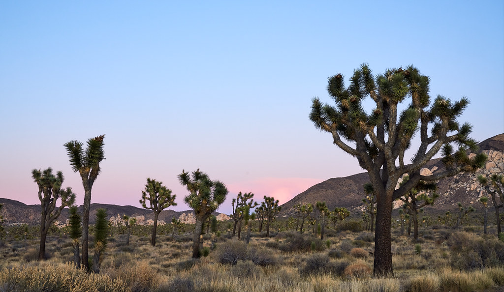
Photo: szeke via Flickr (CC BY-SA 2.0)
Visiting Joshua Tree National Park with limited mobility works best when the trip is organized around paved roads, short hardened paths, and overlooks reached directly from parking areas. The park spans nearly 800,000 acres, and elevations range from roughly 500 feet near the southeastern boundary to 5,814 feet on Quail Mountain. Those changes in elevation create major differences in temperature, vegetation, and walking conditions.
Our team recommends treating the park as a scenic driving experience with carefully chosen stops rather than trying to follow a conventional hiking itinerary. Keys View, Cap Rock, Bajada Nature Trail, Oasis of Mara, Skull Rock, and the edges of Cholla Cactus Garden reveal the park’s defining landscapes with limited walking. This guide explains how to connect them efficiently and where surfaces, slopes, heat, or distance may create barriers.
Planning for Limited Mobility Around Joshua Tree’s Size
Joshua Tree has three main road entrances and no road connecting directly across its northern boundary. The paved interior roads form a broad route from the towns of Joshua Tree and Twentynine Palms through the higher Mojave Desert, then descend through Pinto Basin toward Interstate 10. Driving from the West Entrance to the southern entrance near Cottonwood takes about 90 minutes without stops, so a complete crossing can fill most of a day.
Choosing the Best Entrance When Visiting Joshua Tree National Park With Limited Mobility
The West Entrance, reached from the community of Joshua Tree, provides convenient access to Hidden Valley, Cap Rock, Keys View Road, and the park’s largest concentrations of Joshua trees. It can also develop vehicle lines during busy weekends and holidays. The North Entrance near Twentynine Palms reaches many of the same high desert attractions while often creating a more direct approach to Skull Rock and Split Rock.
The South Entrance connects with Interstate 10 and enters through the lower Colorado Desert near Cottonwood. It is useful for a one way drive across the park, particularly when combined with Pinto Basin and Cholla Cactus Garden. Oasis of Mara sits near the northern edge of the park in Twentynine Palms and can be visited without completing the full interior drive.
What to Arrange Before Entering the Park
Cell service is unreliable across much of the interior, and the park does not operate as a compact attraction where assistance is always nearby. Download maps before arrival and identify each planned stop by name. Entrance fees, pass acceptance, temporary closures, restroom availability, and accessible facility details can change, so confirm current details on the official park site before departure.
- Carry more drinking water than the group normally uses, especially from April through October.
- Bring mobility device repair supplies, including a compact pump for pneumatic tires if applicable.
- Pack sun protection even in winter because shade is scarce at overlooks and parking areas.
- Save an offline map showing Park Boulevard, Keys View Road, Pinto Basin Road, and Cottonwood Springs Road.
- Keep fuel above half a tank before entering because there are no public fuel stations along the interior park roads.
What Visiting Joshua Tree National Park Reveals About Two Deserts
The park protects a meeting ground between the Mojave and Colorado deserts. Elevation largely determines where each ecological community appears. Visitors who remain near the vehicle can still observe the transition clearly because the main road descends from Joshua tree woodland and exposed granite into broad valleys filled with creosote, ocotillo, and cholla.
The Higher Mojave Desert
Joshua trees, Yucca brevifolia, grow mainly in the park’s cooler western and northern uplands. Mature plants can reach 30 to 40 feet, although growth is slow and branching patterns vary widely. Around Hidden Valley and Cap Rock, they rise between rounded monzogranite formations created when deeply buried rock fractured and weathered into stacked boulders. Roadside pullouts make this landscape visible without a long approach.
Winter days at these elevations can be crisp and windy, with freezing nights and occasional snow. Spring usually brings comfortable daytime temperatures, although weekends become busy. Summer heat remains serious even in the uplands, and exposed pavement can become much hotter than the reported air temperature. Autumn often provides manageable temperatures after midday heat begins to ease.
The Lower Colorado Desert
East of the high country, Pinto Basin Road descends into a warmer landscape with longer sightlines and less continuous Joshua tree cover. The Colorado Desert section contains creosote bush, smoke tree, ocotillo, and dense stands of teddy bear cholla. The basin’s open scale is easiest to understand from roadside pullouts, where alluvial fans spread from dark mountain fronts toward the valley floor.
Temperatures in Pinto Basin and near Cottonwood commonly run higher than around Hidden Valley or Keys View. This difference matters for travelers who need extra time transferring from a vehicle or moving between a parking space and viewpoint. During hot weather, our team would schedule lower desert stops early, then return to the higher western portion as temperatures rise.
Accessible Views and Trails to Prioritize With Limited Mobility
The most practical stops combine a short distance with a distinctive view. Paved routes generally provide the greatest predictability, but desert sand can blow across paths, pavement can crack, and grades may feel steeper for manual wheelchair users. Companions should inspect the first section before unloading a heavy mobility device when surface conditions are uncertain.
Keys View, the Park’s Broadest Overlook
Keys View sits at approximately 5,185 feet in the Little San Bernardino Mountains. A short paved route leads from the parking area to views over the Coachella Valley, the San Andreas Fault, Mount San Jacinto, and Mount San Gorgonio. On exceptionally clear days, the Salton Sea may be visible. Air pollution or desert haze often reduces long distance visibility, especially later in the day.
At the overlook, the pavement rises through low shrubs while wind moves across the exposed ridge with little warning. The basin drops sharply beyond the railing, and the San Andreas Fault appears as a long linear feature across the valley floor. Temperatures can feel several degrees cooler than at lower stops, particularly when the sun drops or clouds cross the ridge.
Comparing Short Routes and Roadside Stops
| Location | Approximate distance | Typical surface | Main experience |
|---|---|---|---|
| Keys View | About 0.2 mile | Paved, with some grade | Mountain and fault zone panorama |
| Cap Rock Nature Trail | About 0.4 mile loop | Firm natural surface | Joshua trees and granite formations |
| Bajada Nature Trail | About 0.3 mile loop | Compacted natural surface | Colorado Desert plants |
| Oasis of Mara | About 0.5 mile loop | Primarily paved | Fan palms, water history, and bird habitat |
| Skull Rock | Roadside viewing | View possible from paved roadside area | Eroded granite resembling a skull |
Cap Rock and Bajada Nature Trail are useful for visitors who can manage short distances on firm but potentially imperfect surfaces. Oasis of Mara generally provides the most continuous paved walking option. Skull Rock can be appreciated from near the road, while the surrounding nature trail crosses uneven granite and sandy ground that is poorly suited to most wheeled mobility devices.
Driving Key Corridors When Visiting Joshua Tree National Park With Limited Mobility
A well paced route should minimize repeated transfers while preserving the park’s ecological progression. Begin in the high Mojave Desert if Joshua trees and granite are the priority. Continue through Pinto Basin only if the group has enough time, water, and heat tolerance for a longer day. Attempting every named stop often leads to fatigue before the most accessible viewpoints are reached.
The West and North High Desert Circuit
From either northern entrance, Park Boulevard links Hidden Valley, Cap Rock, roadside Joshua tree stands, Jumbo Rocks, and Skull Rock. Hidden Valley itself has a one mile loop with steps, rocks, and uneven ground, but the picnic and parking area still provides close views of monzogranite walls. Jumbo Rocks offers dramatic formations from the road, although much of the terrain beyond the pavement is sandy and irregular.
Keys View Road branches south from Park Boulevard near Cap Rock. Pairing Cap Rock and Keys View reduces backtracking and creates two contrasting experiences: close study of Joshua tree woodland followed by a high elevation panorama. Allow extra time for slow traffic and wildlife. Desert bighorn sheep are uncommon but possible, while coyotes, jackrabbits, and birds such as cactus wrens are more frequently observed.
Pinto Basin and Cholla Cactus Garden
Pinto Basin Road drops eastward past transition zone vegetation toward Cholla Cactus Garden. The garden’s short loop enters a dense stand of teddy bear cholla, but its natural surface can include loose gravel and uneven sections. Visitors who remain near the parking edge still obtain close views. Cholla segments detach easily and their barbed spines are difficult to remove, so mobility devices, service animals, clothing, and bare skin should remain well clear of fallen pieces.
Quieter Stops That Work With a Vehicle Based Visit
Several worthwhile places receive less attention because they sit beyond the heavily traveled Park Boulevard corridor. These stops suit travelers who prefer to observe plants, geology, and wildlife from parking areas or after a very short transfer. Visiting Joshua Tree National Park with limited mobility becomes easier when one or two of these quieter locations replace a demanding trail rather than being added to an already full schedule.
Cottonwood Spring and the Southern District
Cottonwood Spring lies near the southern end of the park, where fan palms mark a water source used by Cahuilla people and later by miners and teamsters. The palm canopy and surrounding wash can be observed close to the parking area, while routes continuing into the canyon become rougher. Morning is especially useful for birding. Phainopeplas, Gambel’s quail, hummingbirds, and migrating warblers may gather around this concentrated patch of vegetation.
Roadside Geology Beyond the Named Trails
Between Jumbo Rocks and the Pinto Basin descent, broad pullouts reveal exposed monzogranite alongside darker Pinto gneiss, some of the park’s oldest rock. Use designated pullouts rather than stopping on narrow shoulders, which may have soft sand at the pavement edge. Covington Flat and Geology Tour Road lead into less visited country, but their unpaved surfaces can become deeply rutted or sandy. Standard paved corridors provide a safer choice for wheelchair lifts, low clearance vehicles, and passengers who need stable transfer space.
Matching the Day to Desert Conditions
Elevation, sunlight, and wind produce larger temperature differences than many first time visitors expect. A mild morning near Keys View can coincide with uncomfortable heat in Pinto Basin later that day. Vehicle thermometers also understate the heat radiating from pavement. Schedule every transfer that requires extra time before the hottest part of the afternoon, and reserve roadside photography or scenic driving for periods when leaving the vehicle would be tiring.
Seasonal Tradeoffs
| Period | Likely conditions | Planning priority |
|---|---|---|
| December through February | Cool days, freezing nights, strong ridge winds | Carry warm layers and protect hands during wheelchair use |
| March through April | Mild temperatures, occasional wildflowers, heavy visitation | Enter early and expect limited parking at compact lots |
| May through September | Intense sun and dangerous afternoon heat | Keep stops brief and favor higher elevations early in the day |
| October through November | Cooling days with shorter daylight | Complete remote drives before darkness |
Wind, Darkness, and Flash Flooding
Wind matters when operating vehicle doors, ramps, walkers, or lightweight wheelchairs, particularly at Keys View and exposed basin pullouts. Desert darkness arrives quickly behind mountain ridges, and parking surfaces become harder to evaluate after sunset. Rain falling miles away can send water and debris through washes. Never cross a flooded roadway, even when the water appears shallow, because moving water can conceal damaged pavement or a scoured road edge.
Making Each Stop Safer and Less Fatiguing
Repeated transfers frequently create more strain than the total walking distance. Group nearby attractions into a single outing and decide before arrival who will unload equipment, inspect surfaces, and assist on grades. A companion can walk the first 50 feet of an unfamiliar route to identify loose gravel, cross slopes, narrow passages, or missing curb transitions before a wheelchair user commits to the path.
A Practical Mobility Kit
- A seat cushion that does not absorb heat from a parked vehicle
- Gloves for manual wheelchair users crossing rough or sun warmed surfaces
- A reach tool for retrieving dropped items without stepping into vegetation
- A tire patch kit, pump, and device specific tools
- A flashlight or headlamp for evaluating pavement after sunset
- At least one additional layer for exposed overlooks, even when lower elevations feel warm
Protecting Skin, Tires, and Service Animals
Spines from cholla, beavertail cactus, and other desert plants can puncture tires or lodge in footwear. Fallen cholla joints may blend into pale gravel, so service animals should remain on controlled surfaces and away from vegetation margins. Granite can also become hot enough to burn paws or skin. Check surface temperature with the back of a hand before allowing prolonged contact, and use forceps or a comb rather than bare fingers if a loose cactus segment must be moved.
Planning a Comfortable Visit to Joshua Tree National Park With Limited Mobility
A successful limited mobility itinerary connects a few high value landscapes without exhausting the traveler between them. Keys View supplies the regional panorama, Cap Rock provides close Joshua tree and granite scenery, and the Pinto Basin drive shows the transition into the Colorado Desert. Oasis of Mara or Cottonwood Spring can add cultural history, palms, and bird habitat without requiring a backcountry route.
Choose the entrance that minimizes backtracking, place lower elevation stops during the coolest hours, and inspect natural surfaces before unloading mobility equipment. The park’s paved road network reaches remarkably different elevations and ecosystems, allowing travelers to understand its scale from carefully selected overlooks and short paths. With water, offline navigation, repair supplies, and a realistic transfer schedule, the day can remain focused on the landscape rather than preventable logistical problems.
Want to keep exploring? Browse all our Joshua Tree guides and articles for more trip-planning tips and ideas.
Gear & Essentials
Tell us about your trip and we will add what else you will want:
The basics
Worth having in the car whatever the park.
For this trip
Traveling with kids
Bringing a pet
RVing
Backcountry
Winter conditions
On the water
Photography
Accessibility
As an Amazon Associate we earn from qualifying purchases, at no extra cost to you.