Yosemite National Park: The Perfect Weekend Itinerary
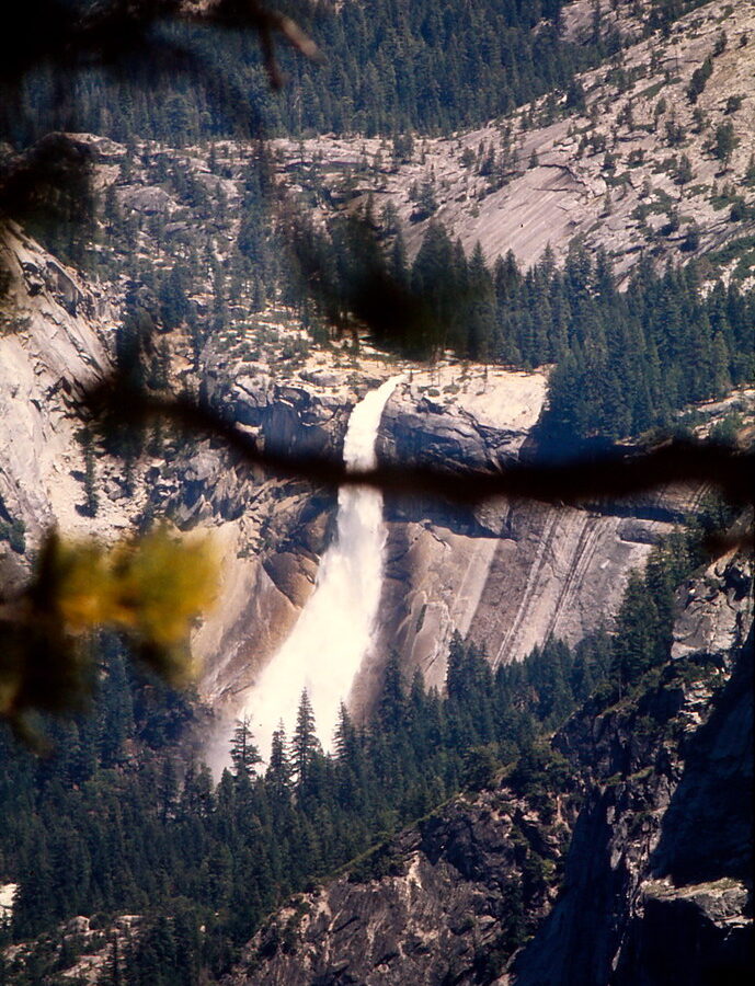
Photo: Ladycliff via Flickr (CC BY 2.0)
Our Yosemite National Park Perfect weekend begins at Tunnel View just after sunrise, when cool air drains through the Wawona Tunnel and the first light reaches El Capitan. From the stone overlook, Yosemite Valley opens beneath you: Bridalveil Fall drops from the south wall, Half Dome rises 8,839 feet in the distance, and the Merced River threads through dark conifer forest. Granite feels cold under your hands, ravens call overhead, and the valley floor remains in shadow while the upper cliffs turn gold.
A weekend gives you enough time for Yosemite Valley’s defining viewpoints, one substantial hike, and several short walks, provided you sleep close to the valley and avoid unnecessary driving. Our route uses Friday evening for arrival, Saturday for waterfalls and granite walls, and Sunday for quieter meadows or a seasonal high country excursion. Drive times below assume moving traffic. Summer congestion, winter chain controls, and road construction can add considerable time.
How Yosemite National Park: The Perfect Weekend Itinerary Works
Yosemite National Park covers nearly 1,200 square miles, but a short visit should concentrate on Yosemite Valley. The valley is approximately seven miles long and sits near 4,000 feet in elevation. Its cliffs expose granitic rock formed deep underground roughly 80 to 100 million years ago, then sculpted by glaciers into the broad U shaped corridor visible today. El Capitan rises about 3,000 vertical feet above the valley floor, while Yosemite Falls descends 2,425 feet in three major sections.
Why One Valley Base Saves Hours
Sleeping in Yosemite Valley provides the most efficient weekend, followed by lodging near El Portal to the west or Wawona to the south. El Portal is roughly a 30 minute drive from the valley in light traffic. Wawona generally requires close to an hour. Communities farther outside the entrances can add two or more hours of round trip driving each day, especially when entrance queues form during summer mornings.
Once inside the valley, park the car and use the pedestrian paths or available public transportation. Many headline sights sit within a compact area connected by mostly level routes. The walk between Yosemite Village and Lower Yosemite Fall is about one mile each way, while Cook’s Meadow, Sentinel Bridge, and the chapel can be combined into a loop of roughly 2.25 miles. Bicycles also work well on designated paved paths, although pedestrians and wildlife frequently cross them.
Yosemite National Park: The Perfect Weekend Route at a Glance
The order below puts exposed viewpoints and popular trails early in the day. It also keeps Friday flexible for travelers arriving from San Francisco, Sacramento, or the southern Sierra. Sunday’s choice depends on road access and season, with Yosemite Valley remaining the dependable option when Tioga Road or Glacier Point Road is closed.
| Day | Primary stop | Key highlight | Typical driving |
|---|---|---|---|
| Friday evening | Tunnel View and Yosemite Valley | First overview, Bridalveil Fall, sunset cliffs | 30 to 60 minutes after entering the park, depending on entrance |
| Saturday morning | Mist Trail corridor | Vernal Fall Footbridge or top of Vernal Fall | None after parking in the valley |
| Saturday afternoon | Lower Yosemite Fall and El Capitan Meadow | Waterfall views and climber watching | About 15 minutes within the valley, traffic permitting |
| Sunday | Glacier Point, Tioga Road, or valley meadows | High country panorama or a quieter low elevation walk | Varies from none to about 90 minutes each way |
What Changes With the Season
Waterfalls usually carry their greatest volume during spring snowmelt, commonly from April into June. Summer brings dependable hiking conditions but heavier traffic and hot afternoons on exposed trails. Autumn has cooler temperatures, lighter waterfall flow, and shorter daylight. Winter turns Yosemite Valley into a quieter snow landscape, although ice can cover paths and storms may require tire chains. Tioga Road, which crosses Tioga Pass at 9,945 feet, and Glacier Point Road are generally unavailable during the snowy season.
Entrance reservations, overnight availability, road status, shuttle operations, fees, and chain requirements can change by date, so confirm current details on the official park site before departure. Carry food for the first evening, refill fuel before entering the park, and download maps in advance. Cellular service is inconsistent outside developed parts of Yosemite Valley.
Friday Arrival on Yosemite National Park: The Perfect Weekend Itinerary
Aim to reach your lodging before dark, but use Tunnel View as the first stop if daylight allows. The overlook sits on State Route 41 immediately east of Wawona Tunnel and requires almost no walking. Late afternoon illuminates Bridalveil Fall and the north wall, while sunset can color Half Dome well after the valley floor has entered shade. Parking is limited, so keep the stop brief when the overlook is crowded.
Choose the Most Efficient Entrance
Four main approaches reach the developed core of Yosemite. State Route 140 through El Portal follows the Merced River and reaches Yosemite Valley without a high mountain pass, making it the most reliable western approach during winter weather. State Route 41 enters near Wawona and passes Mariposa Grove before descending through the tunnel. State Route 120 approaches from the west through Big Oak Flat, while its eastern segment over Tioga Pass operates seasonally.
Arch Rock and the Merced River Approach
Travelers arriving on State Route 140 pass through the narrow Merced River canyon before entering at Arch Rock. Granite walls rise directly above the road, and spring visitors often see cascades pouring from side drainages. Continue toward the valley rather than stopping repeatedly along narrow shoulders. Legal pullouts are limited, and rockfall is an enduring hazard in steep canyon terrain.
South Entrance and Tunnel View
State Route 41 provides the most dramatic first view because the road emerges from Wawona Tunnel directly beside Tunnel View. Visitors approaching from Southern California or Fresno can also pass Mariposa Grove, home to more than 500 mature giant sequoias. Save the grove for a longer trip unless you arrive early Friday, since its access logistics and walking routes consume several hours.
Settle In Without Adding Another Drive
After checking in, assemble a simple meal from supplies brought into the park or use available food service near your lodging. Weekend evenings are poor times for searching distant gateway communities for groceries. Pack Saturday’s water, snacks, rain layer, and traction appropriate to the forecast before sleeping.
- Keep accessible: headlamp, filled water bottles, trail food, and a printed or downloaded map.
- Leave out of the vehicle overnight: all food, scented toiletries, coolers, and visible trash, stored according to park bear regulations.
- Prepare for temperature swings: mornings near the Merced River can feel considerably colder than sunny granite steps above Vernal Fall.
Saturday on the Yosemite National Park Perfect Route
Saturday combines the Mist Trail corridor with the valley’s central landmarks. Starting on foot soon after daylight avoids some congestion and reduces heat exposure. It also improves the chance of finding calm conditions near the waterfalls, where afternoon wind can carry spray across stone steps.
Start With Vernal Fall
From the Happy Isles area, the route to Vernal Fall Footbridge is about 1.6 miles round trip with approximately 400 feet of elevation gain. The paved path climbs steadily beside the Merced River and is steeper than its smooth surface suggests. The footbridge gives a clear view of 317 foot Vernal Fall and makes a sensible turnaround for families or visitors preserving energy for the afternoon.
Continue to the Top Only With Proper Footing
The full climb to the top of Vernal Fall is roughly three miles round trip with about 1,000 feet of gain. The Mist Trail ascends steep granite steps beside the waterfall. During peak runoff, spray soaks the steps and can drench hikers within minutes. Wear shoes with reliable grip, protect electronics, and keep children close to the inside edge. Ice can make this section unsuitable during colder months.
Return Through the Valley’s Waterfall Corridor
After lunch, follow the short loop to Lower Yosemite Fall, which provides close views of the 320 foot lower drop and glimpses of the upper falls. Water volume can fade substantially by late summer. Continue west toward El Capitan Meadow, where binoculars help locate climbers on routes such as the Nose. Stay on durable paths and road pullouts because meadow soils compact easily, damaging the wetland plants and root systems that support deer, songbirds, and hunting coyotes.
Choose One Sunday Route Before You Leave the Valley
Sunday works best when you commit to one geographic area. Glacier Point Road and Tioga Road lead in different directions, so combining them creates hours of backtracking. Check out early, keep food secured in the vehicle, and carry everything needed for the day. Travelers returning west can finish at Glacier Point before leaving by State Route 41. Those continuing toward the eastern Sierra should follow Tioga Road when it is open.
Make Glacier Point the Priority Panorama
Glacier Point stands at 7,214 feet and looks across Yosemite Valley toward Half Dome, Nevada Fall, Vernal Fall, and the Clark Range. The drive from the valley commonly takes about an hour without congestion. Walk the short paved paths around the main overlook before considering an optional detour. Sentinel Dome adds roughly 2.2 miles round trip and a moderate climb, while Taft Point requires a similar distance but ends near abrupt cliff edges. Choose one, since parking and trail time can delay the trip home.
Use Tioga Road for a High Country Finish
When Tioga Road is open, continue past Olmsted Point to Tenaya Lake and Tuolumne Meadows, approximately 8,600 feet above sea level. Olmsted Point reveals the northern face of Half Dome and glacially polished granite surrounding Tenaya Canyon. Tenaya Lake provides an easy shoreline stop, while Tuolumne Meadows introduces a broad subalpine landscape along the Tuolumne River. If high roads are closed, remain in the valley for the mostly level Mirror Lake route, about two miles round trip to the seasonal lake area.
Food, Fuel, and Departure Logistics
Yosemite Valley has no gasoline, and steep approaches consume more fuel than mileage alone suggests. Fill the tank before entering or at a fuel location elsewhere along your approach. Carry enough food to cover trail delays and a late departure, particularly when Sunday traffic slows movement through the Merced River canyon. A Yosemite National Park Perfect schedule depends on avoiding an unnecessary supply run during the busiest part of the weekend.
Pack for a Full Day Away From the Car
Food should remain within arm’s reach while hiking rather than left unattended in a daypack. Black bears have learned to investigate packs, vehicles, and picnic areas for calories. Dispose of scraps promptly and use approved storage at lodging or campsites. For Sunday, prepare a compact kit that works for either high elevation wind or warmer valley conditions:
- Water and lunch: carry enough for the chosen walk and the drive out.
- Layers: include sun protection, insulation, and a waterproof shell.
- Navigation: save offline maps before leaving developed areas.
- Emergency margin: pack a headlamp, basic first aid supplies, and necessary medications.
Keep Saturday Night in the Same Base
Changing lodging after Saturday’s hike wastes daylight and creates another round of parking, unloading, and food storage. Stay in the same valley, El Portal, or Wawona base for both nights when availability permits. On Sunday, place luggage out of sight before visiting trailheads. Mobile coverage weakens quickly along Tioga Road and the southern approaches, so send directions and estimated arrival times before leaving the valley.
Adjust the Weekend to Yosemite’s Seasonal Conditions
The itinerary’s structure remains useful throughout the year, but trail surfaces and road access determine the correct Sunday choice. Spring favors waterfalls, summer opens the high country, autumn brings colder mornings, and winter concentrates travel in Yosemite Valley. Use the following substitutions rather than forcing a route that does not suit the conditions.
| Season | Best emphasis | Likely adjustment |
|---|---|---|
| Spring | Vernal Fall and Yosemite Falls | Carry rain protection and expect wet granite near cascades |
| Summer | Tioga Road and Tuolumne Meadows | Start early to reduce heat and parking delays |
| Autumn | Valley meadows and Glacier Point | Expect low waterfall flow and rapid cooling after sunset |
| Winter | Valley viewpoints and short walks | Replace high road excursions with lower elevation routes |
Plan Around Snowmelt and Summer Heat
April through June usually provides the strongest waterfall experience, but Mist Trail spray and lingering ice can complicate the climb. By midsummer, exposed granite above Vernal Fall becomes hot, even when the valley morning feels cool. Begin early, carry more water than the footbridge distance appears to require, and avoid relying on streams for untreated drinking water. Afternoon thunderstorms can develop over the Sierra crest, making exposed domes poor places to linger.
Use the Valley as the Cold Weather Alternative
Autumn and winter reward a slower valley plan. Walk Cook’s Meadow at first light, visit Bridalveil Fall when access conditions permit, and watch for reflections from Sentinel Bridge. After storms, snow and ice often remain in shaded areas long after sunny pavement has dried. Traction devices can improve footing on packed paths, while tire chains may be required on park roads. Winter daylight is limited, so finish walks before darkness settles beneath the cliffs.
Make the Most of Yosemite National Park: The Perfect Weekend Itinerary
This route protects limited time by keeping Friday simple, placing the Mist Trail early on Saturday, and reserving Sunday for one coherent direction. It includes Yosemite Valley’s essential waterfalls and granite walls without turning the weekend into a sequence of parking searches. Sleeping near the valley and preparing meals, maps, and trail gear the night before create the largest practical savings.
Choose Glacier Point, Tioga Road, or a final valley walk according to season and departure direction. Leave optional detours for the next visit if weather, traffic, or fatigue changes the plan. Yosemite’s scale rewards that restraint. Two well organized days provide time to understand the valley’s glacial form, walk beside the Merced River, and see the high Sierra landscape that surrounds it.
Want to keep exploring? Browse all our Yosemite guides and articles for more trip-planning tips and ideas.
Gear & Essentials
Tell us about your trip and we will add what else you will want:
The basics
Worth having in the car whatever the park.
For this trip
Traveling with kids
Bringing a pet
RVing
Backcountry
Winter conditions
On the water
Photography
Accessibility
As an Amazon Associate we earn from qualifying purchases, at no extra cost to you.